

Du Toit’s Kloof Memorial Hut
Hut Capacity (for bookings)
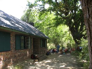
The Du Toit’s Kloof Memorial Hut is large and peaceful with shady trees, a pool, braai area, and adjacent camping just 100m from the car. It’s a convenient base for hiking and climbing in the Du Toit’s valley, and for accessing Agtertafelberg Hut.
The Cape Town Section has entered into a Management Agreement with the Worcester Section. Worcester is now responsible for the management of the Du Toit’s Kloof Hut and property for an initial period of five years, with effect from 1 December 2024.
Members will continue to have free use of the property during the day for hiking, climbing, parking (including overnight) and picnics. For codes and access arrangements as well as booking overnight visits, please see “Booking” below.
History
After World War II, the Committee decided to build a memorial mountain hut in the Boland to commemorate members who had lost their lives in the war. Various areas were considered, but the then wild and remote Du Toit’s Kloof was chosen in 1947 when the Du Toit’s Kloof pass was still under construction. Two committee members visited landowner Hennie de Wet, who donated it to the Club. In recognition of his generous gift, De Wet was elected an Honorary Life Member of the Club. The hut was completed in 1949 and about 250 people attended the Club President’s official opening of the Du Toit’s Kloof Memorial Hut. A bronze plaque bearing the names of Club members killed during the war was placed above the main fireplace, but this has since been stolen.
| Where | Du Toit’s Kloof Mountains, close to the N1 |
| Drive time | 1 hour from Cape Town |
| Walk-in time | 2 minutes |
| Activities | Camping, walking, rock climbing, swimming, overnighting in the hut |
| Size | 3ha |
| Capacity | 12 inside the hut (6 in each room, in two triple bunks) 5 levelled campsites outside the hut |
| Ownership | Cape Town Section. MCSA-CT has entered into a Management Agreement with the Worcester Section, so that Worcester is responsible for the management of the Du Toit’s Kloof Hut and property with effect from 1 December 2024. |
| Map | 1:50 000 – 3319CA Bain’s Kloof |
| Permit | Not required for access to the hut and associated Club property, but you will need a CapeNature permit for walking in the area and you must please carry your Club membership card |


